|
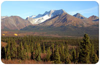
The relatively unexplored southeast Yukon offers some
true jewels to be discovered. Would you like to explore the area on a
guided special tour with us, in addition to staying at our lodge? We
live in this region and know the many hidden treasures and remote
trails that lead into spectacular scenery. Let us know about your
interests, and we can plan a customized tour for
you.
Whether it's a 3 – 4 day sightseeing tour or a longer trip including
various activities, we have plenty of ideas and amazing destinations to
offer. Many places are ideal for hiking, ranging from easy day walks
following trails to demanding multi-day excursions into the rugged
mountain wilderness. For paddlers, short outings on lovely lakes or
multi-day river trips are also available. We will be travelling in our
minivan and sleeping in tents at night. These customized tours are
offered for parties of 2 or more, from mid-June to
mid-September.
We specialize in the following regions, which can be combined together:
 |
Tungsten
Road
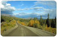
A 200-km-long gravel road leads up to the Tungsten Mine in the border
area between the Yukon and Northwest Territories. Initially, the road
winds its way through lovely pine and spruce forests before climbing up
into the wild yet romantic Hyland River Valley. Open tundra plains lead
up into the mountains and across the Yukon/ NWT border, then down into
the remote Flat River Valley and the mining town of Tungsten. The
scenery — with snow and ice-covered mountains and untamed wilderness —
at the edge of Nahanni National Park is outstanding. A sure highlight
is the natural hot springs, which invite visitors for a relaxing soak.
Ideal for hiking, mountaineering, bathing in the hot springs or for a
sightseeing tour.
|
| |
|
 |
North
Canol Road
A narrow gravel road leads from the First Nations village of Ross River
for 230 km, northbound through complete wilderness to the MacMillan
Pass at the Yukon/Northwest Territories border. The first highlight of
the incredible trip is the crossing of the mighty Pelly River on a tiny
barge. Next, the road continues through extensive spruce and poplar
forests, which offer a breathtaking array of colours each fall. A
number of lovely lakes nearby invite exploration by canoe. Further down
the road, cross the foaming South MacMillan River and travel through
wide-open bush and tundra landscapes, with unparalleled views of the
glaciated Itsi Mountains. Finally, the road climbs into a high valley
through ever-more-mountainous scenery up to MacMillan Pass at 1366
metres.
Ideal area for hiking, mountaineering, canoeing on lakes/rivers or for
a
sightseeing tour.
|
| |
|
 |
South
Canol Road
This 230-km-long narrow gravel road leads from the Campbell Highway
southbound to Johnson's Crossing on the Alaska Highway. The road starts
at the impressive Lapie Canyon and continues up through ever-changing
forest and mountain scenery, while crossing a few sparkling streams
along the way. Eventually the road reaches an idyllic open plateau,
featuring charming rivers and picturesque lakes. This is beaver
country,
with countless dams and backed-up ponds in the area. Further on, the
winding road crosses the mountains, drops down to awesome Quiet Lake
and leads along the peaceful, meandering Nisutlin River to its southern
terminus.
Ideal for hiking, canoeing on lakes/rivers, or for a sightseeing tour.
|
| |
|
 |
Campbell
Highway
The Campbell Highway leads from Frances Lake westbound through
undulating and heavily treed Yukon scenery. Shortly after departing,
this road crosses the continental divide at Finlayson Lake, and
continues down alongside the mighty Pelly River. A narrow track up the
lovely Ketza River Valley allows for a rewarding side trip into remote
mountain ranges. Next, along the main highway is the turn off to the
First Nations settlement of Ross River. Highlights of this area are
fossilized dinosaur footprints, the impressive Lapie Canyon, and a
thrilling swing bridge near the ferry crossing at the Pelly River.
Further to the west is Faro, an historic mining town and an excellent
starting point for many side trips. Finally, the road skirts the long,
narrow Little Salmon Lake, allowing great views down to the mighty
Yukon River shortly before reaching Carmacks.
Ideal for a sightseeing tour, hiking in the Ketza River Valley, for a
3-day walk along the Dena Cho Trail or for a 2 – 7 day canoe trip down
the Pelly River.
|
| |
You see, there are many things to discover in the
southeast Yukon.
If you are interested in a special tour, get in touch with us and we
will work out a proposal for an itinerary that suits your wishes. These
special tours are particularly — but not only — addressed to our many
regular guests who would like to expand their horizons beyond the
Frances Lake region.
   

|